Finalising the categories in which I would like to present my work will be as follows:
The Control Tower- Including 5 different towers this is the first structure I was intrigued with when documenting Second World War areas. It is also an important building to the context of an airfield you wouldn’t find them on all military units.
The Hangar- Intrigued with the different types of hangar, it seems hangars are easily utilised for different purposes and can be renovated. An important structure to the airfield.
The Defensive Structure- I will include different types of structures such as pill boxes, outposts and hopefully an airfield dispersal pen. As long as their purpose had some sort of shelter for an airfield attack, again very important structure to the integrity to the airfield.
The Runway- *New category* that focuses on the actual part of the airfield that aircraft would have taken off from. Some still in use and others derelict or repurposed.
The Bird’s Eye View- *New Category*(see below for greater context to these images) Using imagery from MOD archive I have layered an older aerial image (mostly from the 1950s) with an image from 2015-2017. This is a great way to visually demonstrate the imprint of the airfield, it may not obvious from the ground by from the sky opens up a whole new perspective.
The Miscellaneous- *New Category* Not loving the title but finding it hard to come up with something else. This section includes some of the other structures that I find interesting, some are commonly found like the range butts others like the Shortland dock is the only one of its kind.
That will make a total of 30 images, it doesn’t cover every site in NI and this is why I have spilt them up this way. As so I’m not tied to every area rather, I can present what looks best photographically.
I also need to sort captions for each image!
The Bird’s Eye View
Having been inspired by various practitioners like Gary McLeod, Mark Klett and Byron Wolfe I wanted to include a rephotography element (not sure if this is or rather reappropriated image?). I also felt seeing the airfields from some height put into context the magnitude in which these runways/dispersals can still be seen on our landscape, even if faint. I shot oblique aerial photographs in Module 4, but this was not the best angle and weather wasn’t great. I have also used vertical aerial imagery to determine what structures date Second World War and have compared them to up to date imagery.
I wondered if I could find anymore aerial imagery from Second World War, although I couldn’t find much when the stations were in use, I found a few from the 50s,60s. These images still had much of the buildings and runways intact before being regenerated. The film library is a bit hit and miss and so I had to go through every film if I thought they had flown that flight plan. Once I had selected the right frame, I scanned the negative in at 1600ppi. I wouldn’t be able to shoot my own vertical images and so I utilised up to date imagery that was used for RAF100 and Action Station programme with Living Legacies. To start I wasn’t sure how I was going to use both, but I thought I would keep it simple. I just layered the images and reduced the opacity, I liked the effect. I like that it is not obvious and so it draws the viewer closer to examine the image, I have edited 5 images in this way.
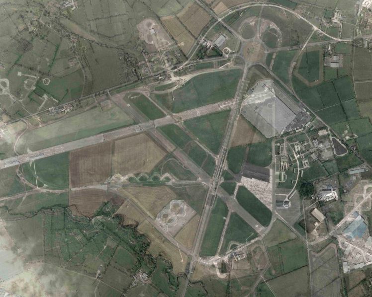
Images using MOD archive and edited by Laura Wing
Image shows Nutts Corner in 1951 and 2017.
